Hurricanes Season
Hanna Moving North, Ike Now a Major Hurricane:
Chris Dolce, Meteorologist, The Weather Channel
8:19 p.m. ET 9/3/2008
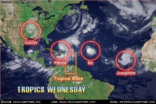
Tropical Storm Hanna is showing signs of reorganization and slightly increased in intensity this evening. Meanwhile, farther east Ike has become the third major hurricane of the 2008 Atlantic hurricane season. Josephine, a tropical storm, is struggling with wind shear in the far eastern Atlantic.
Watch the latest hurricane forecast.
Tropical Storm Hanna
Hanna is showing signs of organization and strengthening this evening. Top sustained winds have increased slightly to 65 mph. Hanna's pressure has also dropped several millibars through the afternoon.
It also has expanded greatly in overall size today. Tropical storm-force winds now extend 290 miles north of the center of circulation.
View the Hanna Tracker.
Further organization and strengthening of Hanna is anticipated tomorrow. It also may regain hurricane status sometime Thursday into Friday.
Because it is still forecast to strengthen back to a hurricane, hurricane warnings are posted for the northwestern and central Bahamas. A tropical storm warning is in effect for the southeastern Bahamas and the Turks and Caicos Islands.
After heading south yesterday, Tropical Storm Hanna is now heading to the north at a faster pace at 14 mph. Additional increase in forward speed is likely. Hanna will move through all of the Bahamas tonight and Thursday.
View the latest projected path for Hanna.
Drenching, deadly rains have been occurring over Hispaniola and the southeastern Bahamas because of Hanna. Flooding rains have already occurred over the Dominican Republic but especially over Haiti which is still recovering from Fay and Gustav's rains. Reports indicate that Hanna's tremendous rainfall has killed at least 25 people in Haiti due to flooding and mudslides.
Puerto Rico has also been impacted by Hanna with flooding rains, landslides and high surf. The island continues to be drenched and flood watches are in effect through this evening.
The storm already has churned the ocean waters off the Southeast coast. Earlier this week, numerous rescues by lifeguards were carried out along the beaches of South Carolina, Georgia, and North Carolina all due to the dangerous rip currents. The high rip current threat will last through the remainder of the week.
Coastal residents of South Carolina and North Carolina should monitor the track and development of Hanna. By Friday afternoon, Tropical Storm or perhaps Hurricane Hanna will be nearing the Southeast U.S. coast. The Weather Channel's and weather.com's projected path takes Hanna's center of circulation towards an eventual landfall close to the South Carolina/North Carolina border.
From the Carolinas, Hanna may spread rain and wind up the East Coast of the United States through Saturday.
Tropical Depression Gustav
The remnants of Gustav are soaking nearly all of Arkansas and portions of Mississippi, eastern Oklahoma, western Tennessee, and much of Missouri as it sits and spins over southwestern Arkansas.
Rainfall totals have been tremendous. Here are some selected totals courtesy of the Hydrometeorological Prediction Center:
Jigger, La. - 20 inches
Larto Lake, La. - 19 inches
Near Jonesville, La. - over 17 inches
Bude, Miss. - over 11 inches
Hamburg, Ark. - over 11 inches
West Monroe, La. - over 10 inches
Hot Springs, Ark. - nearly 9 inches
The flooding rains from Gustav will slide north and east through Missouri and eventually into Illinois; providing a very wet day for the cities of St. Louis and Chicago on Thursday.
Hurricane Ike
Elsewhere in the Atlantic Basin, Ike continues to gather strength. It is now a category three hurricane with top winds of 115 mph.
It is located more than 645 miles east-northeast of the Lesser Antilles.
Hurricane Ike will trek west-northwest then west during the remainder of the week. Further strengthening is possible over the next few days.
Fortunately, there are plenty of days still ahead to monitor Ike's progress. Residents of the Bahamas should monitor the progress of Ike carefully the next several days. At this moment it is too early to tell if Ike would have any impact on the United States.
You can view the projected path here.
View the Ike Tracker.
Tropical Storm Josephine
Tropical Storm Josephine is in the far eastern Atlantic. It is located about 305 miles west-southwest of the southernmost Cape Verde Islands. Top winds have decreased to 60 mph.
The tropical storm is already feeling the affects of wind shear and the entrainment of dry air into its circulation. Josephine will also begin to encounter cooler ocean waters beginning tomorrow. These three factors combined (shear, dry air, and cooler waters) will weaken Josephine during the next two days.
Josephine will continue to move away from the Cape Verde Islands on a western track but then gradually turn to the west-northwest churning over the open waters of the east-central Atlantic.
You can view Josephine's projected path here.
For the latest on the busy tropics, stay tuned to The Weather Channel and for updates here on weather.com.
About Me

- Mike Caira
- Hello, and welcome to Mike Caira's Business News Blog. I am a student currently attending the University of North Florida. I'm studying business, specifically finance. Look me up on Facebook and feel free to add me!

My Blog List


Updated Image of the Tropics
Sept. 3, 2008
Earth's Lights:

At Night From Space
No comments:
Post a Comment